Research, Expert’s reports, Services & Innovation

Notre équipe d’experts de niveau international en collaboration avec le monde de la recherche, des  ONG, des organismes publics et privés nationaux ou pilote ou participe à des projets de recherche, d’études, de services dans les domaines de la réduction des risques, de l’adaptation aux changements climatiques, de gestion raisonnée de nos ressources, de l’appui aux collectivités, aux entreprises pour la réduction de leur vulnérabilité face aux aléas, à leurs conséquences directes et indirectes.

RESEARCH, EXPERT’S REPORTs INNOVATION AND SERVICES

Our experts offer 25 years of international experience in the sensitive fields of - natural and technological risk assessment and reduction, - assessment of the impact of man-made or natural phenomena on natural resources, crisis management, risk vulnerability and impact reduction, and climate change impact and adaptation assessment.

Thanks to our extensive international experience, we offer assistance in project management, training, feedback, and the development of strategies to ensure the resilience of your systems or territories.

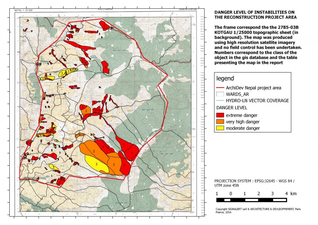
From diagnosing vulnerability and exposure to phenomena and their potential intensity, to implementing crisis management or feedback tools, thanks to its experts SIGNALERT is recognized for its skills, implemented in relation to the following natural phenomena:

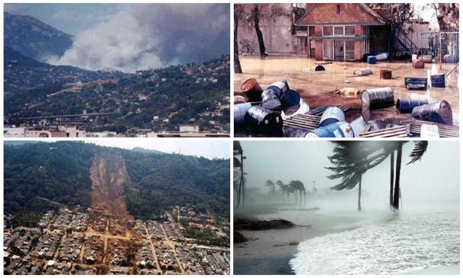
Earthquakes, tsunamis, volcanic eruptions, cyclones, typhoons and hurricanes, tornadoes, marine storms and coastal floods, torrential floods, mudslides, forest fires, avalanches, landslides and ground collapse, drought, sea-level rises and coastal erosion, and hail.

Our expertise also covers man-made phenomena:

Technological and industrial accidents, water and marine pollution, air pollution, NATECH, urban rainwater runoff.

Union Europenne, Banque Mondiale, AFD, Expertise France mais aussi Haut Comité Français à la résilience Nationale ou différentes collectivités font appel à notre expertise pour l’appui dans le mise en oeuvre de procédures complexes. Qu’il s’agisse de subvention, de montage de dossier du Fonds de Prévention des Risques Majeurs (FPRNM), de PAPI, de PPCI, nous pouvons vous appuyer dans le montage des dossiers, le pilotage des projets, les expertises contradictoires.

INNOVATION

We are constantly innovating to improve existing approaches or introduce new tools, be it analysis or modelling tools or in the Signalert app, which has become the tool for citizens’ and organizations’ involvement in real-time risk monitoring.

Signalert has introduced several new intensity scales to qualify the gravity of natural phenomena, for instance earthquakes with the scale shown below. These tables exemplify the principle of graduated intensity scales used in the smartphone app to qualify certain phenomena if the proposed visual indicators are available to you.

Table 1: Markers of the intensity experienced by the witness

Table 2: Markers of levels of damage experienced by the witness

SOME OF OUR REFERENCES

Natural and technological risks

  • assistance technique pour la DG INTPA VIA LA the EU Global NDC Facility. Support de l’identification de missions et projets  pour le programme “Strengthened Africa-EU partnership on Space, Earth Observation, climate services and related services”. Programme 2022-2027.

  • Elaboration of Plans for Natural Risk Reduction in Urban Areas for two Priority Municipalities in Haiti.

  • National Strategy for Climate Change for the Republic of Djibouti.
  • Elaboration of a national strategy for integrated urban planning and management, taking into account flood risk prevention and adaptation to climate change; Rainwater Management and Climate Change Adaptation Programme in Senegal
  • Mapping of ground instability and rockfalls in the Sindhupalchok district of Nepal as part of a post-earthquake reconstruction project and use of the SIGNALERT smartphone app to monitor phenomena, for a French NGO.
  • Diagnosis and reduction of vulnerability to flood risks or other natural risks on industrial, hospital, public, commercial, storage and logistics sites, as well as individual and collective housing
  • Drafting of a methodological guide for the study of tsunami hazards for new coastal or harbour projects on behalf of a pool of French industrial actors.
  • Djibouti National Housing Strategy, Review of the legal and regulatory framework for construction in Djibouti to integrate measures to reduce vulnerability to earthquakes and floods in housing construction.
  • Feedback on the Tohoku earthquake and tsunami, March 2011, Japan, French Earthquake Engineering Association (APFS).
  • Critical analysis of the European Commission's financial tools capable of supporting disaster prevention activities. European Commission, Environment Directorate-General
  • Elaboration of the Seychelles' natural risk profile
  • Establishment of a methodology to assess the costs of direct and indirect flood damage in Romania.
  • Coordination of the European SCHEMA project dedicated to the development of an approach to assess tsunami risk vulnerability in the Euro-Mediterranean area.

Crisis management, early warning

  • Needs assessment for the implementation of an early warning system in Togo.
  • Diagnosis of the Businee continuity plan to manage the risk of flooding by the Seine River at the Georges Pompidou European Hospital. Expert’s report on existing measures and proposals for improvement.
  • Final evaluation of the Capacity Building Project for Sustainable Management of the Flood Early Warning System in Haiti.
  • Formulation of terms of reference for a geographic information system for crisis and major risk management in four test provinces of Morocco.
  • Crisis management plan to deal with flood risks for several industrial sites in the Paris region

CLIMATE CHANGE AND SUSTAINABLE MANAGEMENT OF NATURAL RESOURCE & ENVIRONMENT

  • Training of state and non-state actors on local and national risk assessment and adaptation to climate change, Mauritania, Senegal.
  • Assessment of the water sector’s vulnerability to climate change in Haiti.
  • MONITEAUMIN Project - Identification and assessment of natural and anthropic constraints and of climate change impacts on mineral water production sites using high resolution satellite imagery in France, Argentina and Indonesia.
  • Pumping trial and dewatering measures on an AEP (drinking-water supply) site supplying a plant in Seine-et-Marne (France), 2008.
  • Mapping of wetlands using photo-interpretation on aerial images in Basse-Normandie, in the Vire and Orne basins.
  • WARESYS project – bilateral Franco-Egyptian cooperation – supporting the search for water resources in desert areas through spatial imaging.

Technological Risks, NATECH

  • Determination of the impacts of Boilover and UVCE scenarios on the buildings and population of the municipality of Vitry-sur-Seine (France).
  • Expert’s report on exposure to natural risks (earthquakes, floods, tsunamis, fire, marine flooding) at a dozen petrochemical sites in Algeria, vulnerability analysis, proposal of impact reduction recommendations

OUR PARTNERS AND CUSTOMERS

Our partners

Our Clients

A project initiated and supported by